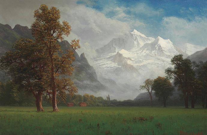
Jungfrau. The Jungfrau, at 4,158 meters is one of the main summits of the Bernese Alps, located between the northern canton of Bern and the southern canton of Valais, halfway between Interlaken and Fiesch. Together with the Eiger and Monch, the Jungfrau forms a massive wall of mountains overlooking the Bernese Oberland and the Swiss Plateau, one of the most distinctive sights of the Swiss Alps. The summit was first reached on August 3, 1811, by the Meyer brothers of Aarau and two chamois hunters from Valais. The ascent followed a long expedition over the glaciers and high passes of the Bernese Alps. It was not until 1865 that a more direct route on the northern side was opened. The construction of the Jungfrau Railway in the early 20th century, which connects Kleine Scheidegg to the Jungfraujoch, the saddle between the Monch and the Jungfrau, made the area one of the most-visited places in the Alps. Along with the Aletsch Glacier to the south, the Jungfrau is part of the Jungfrau-Aletsch area, which was declared a World Heritage Site in 2001. The name Jungfrau, which refers to the highest of the three prominent mountains overlooking the Interlaken region, along with the Monch and the Eiger, is most likely derived from the name Jungfrauenberg given to Wengernalp, the alpine meadow directly facing the huge northern side of the Jungfrau, across the Trummelbach gorge. Wengernalp was so named for the nuns of Interlaken Monastery, its historical owner. Contrary to popular belief, the name did not originate from the appearance of the snow-covered mountain, the latter looking like a veiled woman. The virgin peak was heavily romanticized as goddess or priestess in late 18th to 19th century Romanticism. Its summit, considered inaccessible, remained untouched until the 19th century. After the first ascent in 1811 by Swiss alpinist Johann Rudolf Meyer, the peak was jokingly referred to as Mme Meyer. Politically, the Jungfrau is split between the municipalities of Lauterbrunnen and Fieschertal. It is the third-highest mountain of the Bernese Alps after the nearby Finsteraarhorn and Aletschhorn, respectively 12 and 8 km away. But from Lake Thun, and the greater part of the canton of Bern, it is the most conspicuous and the nearest of the Bernese Oberland peaks; with a height difference of 3,600 m between the summit and the town of Interlaken. This, and the extreme steepness of the north face, secured for it an early reputation for inaccessibility. The Jungfrau is the westernmost and highest point of a gigantic 10 km wall dominating the valleys of Lauterbrunnen and Grindelwald. The wall is formed by the alignment of some of the biggest north faces in the Alps, with the Monch and Eiger to the east of the Jungfrau, and overlooks the valleys to its north by a height of up to 3 km. The Jungfrau is approximately 6 km from the Eiger; with the summit of the Monch between the two mountains, 3.5 km from the Jungfrau. The Jungfraujoch is the saddle between the Jungfrau and the Monch and the Eigerjoch is the saddle between the Monch and the Eiger. The wall is extended to the east by the Fiescherwand and to the west by the Lauterbrunnen Wall, although it follows different directions from the Jungfrau and the Eiger. The difference of altitude between the deep valley of Lauterbrunnen and the summit is particularly visible from the area of Murren. From the valley floor, west of the massif, the altitude gain is more than 3 km for a horizontal distance of 4 km. The landscapes around the Jungfrau are extremely contrasted. In contrast to the vertiginous precipices of its northwest, the mountain's southeastern side emerges from the upper snows of the Jungfraufirn, one of the main feeders of the Aletsch Glacier, at around 3,500 meters. The 20-kilometer-long valley of Aletsch on the southeast is completely uninhabited, and is surrounded by neighboring valleys with similar landscapes. The area as a whole constitutes the largest glaciated area not just in the Alps, but also well as in Europe. In 1811, the brothers Johann Rudolf and Hieronymus Meyer, sons of Johann Rudolf Meyer, the head of a rich merchant family of Aarau, along with several servants and a porter picked up at Guttannen, first reached the Valais by way of the Grimsel, and crossed the Beich Pass, a glacier pass over the Oberaletsch Glacier, to the head of the Lotschen valley. There, they added two local chamois hunters, Alois Volken and Joseph Bortis, to their party and traversed the Lotschenlucke before reaching the Aletschfirn, where they established the base camp, north of the Aletschhorn.
more...


