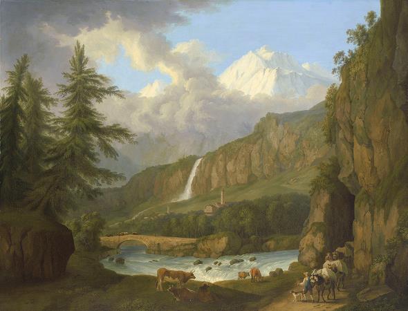
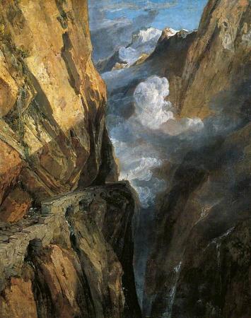
Gotthard Pass. The Gotthard Pass or St. Gotthard Pass at 2,106 m is a mountain pass in the Alps traversing the Saint-Gotthard Massif and connecting northern and southern Switzerland. The pass lies between Airolo in the Italian-speaking canton of Ticino, and Andermatt in the German-speaking canton of Uri, and connects further Bellinzona to Lucerne, Basel, and Zurich. The Gotthard Pass lies at the hearth of the Gotthard, an important north-south axis in Europe, and it is crossed by three major traffic tunnels, each being the world's longest at the time of their construction: the Gotthard Rail Tunnel, the Gotthard Road Tunnel and the Gotthard Base Tunnel. With the Lötschberg to the west, the Gotthard is one of the two main north-south routes through the Swiss Alps. Since the Middle Ages, transit across the Gotthard played an important role in Swiss history, the region north of Gotthard becoming the nucleus of the Swiss Confederacy in the early 14th century. The Gotthard Pass lies on the main watershed of the Gotthard massif, a massif lying at the heart of the Swiss Alps, between the cantons of Valais, Ticino, Grisons and Uri. The pass itself is the lowest point between the summits of Pizzo Lucendro and Pizzo Centrale. It connects the cantons of Uri and Ticino, its summit being located in the latter canton, about 2 km south of the border with Uri. The valleys connected by the pass are that of the river Reuss, named the Urseren, and that of the river Ticino, named Valle Leventina. The Gotthard axis is the most important route between Central Switzerland as well as most of the northern part of the country and the southern region of Ticino. It is the most direct link between Zürich and Lugano and also between some regions of northern Europe and Italy. The nearest towns are Hospental near Andermatt and Airolo, respectively in the valleys of Urseren and Leventina. The region of Andermatt lies at the foot of the Furka and Oberalp Passes connecting the Rhone and Rhine Valleys thus making the Gotthard area a strategic place for transports and military. Just southeast of the culminating point of the Gotthard Pass, at an elevation of about 2,090 metres above sea level, are several lakes. The largest is named Lago della Piazza and has a surface of 3.94 hectares. South of Lago della Piazza are the Hospice and National Museum, as well as a hotel and restaurants. Another official road sign displaying an elevation of 2,091 metres lies there. A few kilometres away and slightly above the Gotthard Pass are found two large dams and artificial lakes: Lago di Lucendro at the foot of Pizzo Lucendro and Lago della Sella at the foot of Pizzo Centrale. They are respectively part of the Reuss and Ticino basin, although both are located within the canton of Ticino. Further information: Schöllenen Gorge § History Though the pass was locally known in antiquity, it was not generally used until the early 13th century because travel involved fording the turbulent Reuss, swollen with snowmelt during the early summer, in the narrow steep-sided Schöllenen Gorge, below Andermatt. The first wooden bridge across Schöllenen Gorge was built around 1220, and in the following years the pass rapidly gained in importance. The bridge permitted traffic to follow the Reuss to its headwaters and over the saddle at the top—a continental divide between the Rhine, which flows into the North Sea and the river Ticino towards Milan, which after leaving Switzerland flows into the Po and ultimately into the Adriatic Sea. The Gotthard Pass was formerly known as Monte Tremolo. A chapel dedicated to Saint Gotthard of Hildesheim, who was considered the patron saint of mountain passes, was built on the southern slope of the pass and consecrated by the archbishop of Milan in 1230. The pass soon became known after the saint, by as early as 1236. The opening of the Schöllenen Gorge for traffic was an important factor in the original Swiss Confederacy. The three regions of Uri, Schwyz and Unterwalden gained imperial immediacy under the Hohenstaufen emperors still in the first half of the 13th century. An important aspect of the early confederacy, expressed in the Pfaffenbrief of 1370, was the guarantee of peace along the road from Zürich to the Gotthard Pass. The Swiss also had an interest in extending their influence south of the Alps to secure the trade route across the pass to Milan. Beginning in 1331, they initially exerted their influence through peaceful trade agreements, but in the 15th century, their involvement turned military. 1403 the upper Leventina, as the valley south of the pass is called, became a protectorate of Uri.