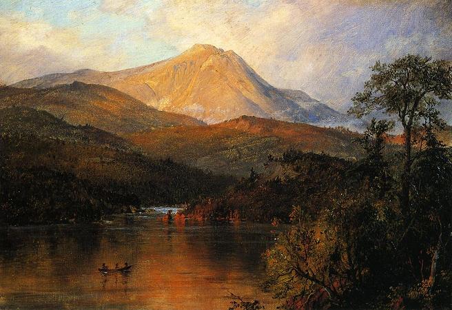
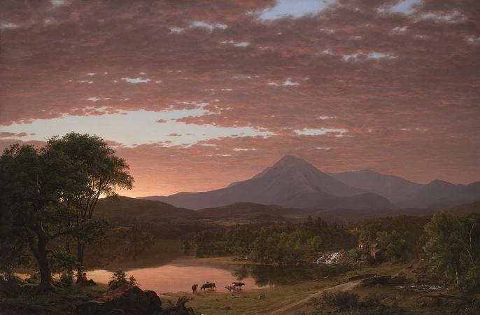
Mount Katahdin. Mount Katahdin is the highest mountain in the U.S. state of Maine at 5,267 feet. Named Katahdin by the Penobscot Native Americans, which means The Greatest Mountain, it is located within Northeast Piscataquis, Piscataquis County, and is the centerpiece of Baxter State Park. It is a steep, tall massif formed from a granite intrusion weathered to the surface. The flora and fauna on the mountain are typical of those found in northern New England. Katahdin was known to the Native Americans in the region, and was known to Europeans at least since 1689. It has inspired hikes, climbs, journal narratives, paintings, and a piano sonata. The area around the peak was protected by Governor Percival Baxter starting in the 1930s. Katahdin is the northern terminus of the Appalachian Trail, and is located near a stretch known as the Hundred-Mile Wilderness. In 1967, Mount Katahdin was designated as a National Natural Landmark by the National Park Service. The mountain is commonly called just Katahdin, though the official name is Mount Katahdin as decided by the US Board on Geographic Names in 1893. Katahdin is in Baxter State Park, which is in east central Piscataquis County, about 25 mi northwest of Millinocket. It is on the drainage divide between the East and West branches of the Penobscot River. The mountain massif itself consists of multiple peaks. Baxter Peak is the tallest, and is the official northern terminus of the Appalachian Trail. South Peak and Pamola Peak are southeast and east of Baxter Peak, respectively, along the Knife Edge ridgeline, while Hamlin Peak lies to the north. The third highest mountain in Maine, Sugarloaf Mountain at 1,295 m, is over one hundred miles to the southwest. There is low lake country to the south and west of Katahdin, and lowlands extending east to the Atlantic and north to the Saint Lawrence River in Canada. It is commonly thought that Katahdin is the first place in the United States mainland to receive sunlight in the morning, but this is incorrect. Other mountains, lower in elevation but farther to the east or southeast, depending on the season, see the first sunrise of the day. Katahdin is part of a laccolith that formed in the Acadian orogeny, when an island arc collided with eastern North America approximately 400 million years ago. On the sides of Katahdin are four glacial cirques carved into the granite by alpine glaciers and in these cirques behind moraines and eskers are several ponds. In Baxter State Park, many outcrops of sedimentary rocks have striations, whereas Katahdin Granite and Traveler Rhyolite lava have weathered surfaces on which striations are commonly not preserved. Bedrock surfaces of igneous rocks which have been buried by glacial sediments and only recently exposed have well preserved striations, as in the vicinity of Ripogenus Dam. Several outcrops of sedimentary rocks along the Patten Road show striations, especially on the north side of the road at Hurricane Deck. A few outcrops near the Pattern Road just north of Horse Mountain are striated, as are several outcrops of sedimentary rocks along the road from Trout Brook Farm northward to Second Lake Matagamon. Fauna include black bear, deer and moose as well as black flies and mosquitos in the spring. A subspecies of Arctic butterfly, known as the Katahdin Arctic is specific to the area, and is currently listed as endangered.Among the birds are Bicknell's thrush and various songbirds and raptors. A study of the animal communities was published by Irving H. Blake in 1926. The flora includes pine, spruce, fir, hemlock, beech, maple, birch, aspen, and Diapensia lapponica. Katahdin is referred to 60 years after Field's climb of Agiokochuk in the writings of John Gyles, a teenage colonist who was captured near Portland, Maine in 1689 by the Abenaki. While in the company of Abenaki hunting parties, he traveled up and down several Maine rivers including both branches of the Penobscot, passing close to Teddon. He remarked that it was higher than the White Hills above the Saco River. Among some Native Americans, Katahdin was believed to be the home of the storm god Pamola, and thus an area to be avoided. The first recorded climb of Catahrdin was by Massachusetts surveyors Zackery Adley and Charles Turner, Jr. in August 1804. In the 1840s Henry David Thoreau climbed Katahdin, which he spelled Ktaadn; his ascent is recorded in a well-known chapter of The Maine Woods. A few years later Theodore Winthrop wrote about his visit in Life in the Open Air. Painters Frederic Edwin Church and Marsden Hartley are well-known artists who created landscapes of Katahdin.